The Dark Room

The McGill Library digitization team

Main menu

Skip to primary content
Skip to secondary content
  • Home
  • About

Tag Archives: Nautical charts — Bay of Fundy — Early works to 1800.

1745 map – A Description of the Bay of Fundy

Posted on July 10, 2014 by Sarah Severson
Comment

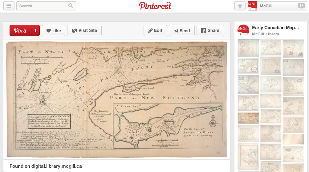
All 50 maps in the  W. H. Pugsley Collection of Early Canadian Maps are now available for download in our catalogue and a growing selection are on Pinterest if you want to share them.

1745 - A Description of the Bay of Fundy map

1745 - A Description of the Bay of Fundy map

Posted in Map Room, Rare Books and Special Collections | Tagged Nautical charts -- Bay of Fundy -- Early works to 1800. | Leave a comment

Digitization at McGill Library

Subscribe

Categories

  • Behind the scenes at McGill
  • Digital Resources
  • eScholarship
  • Found in the margins
  • Islamic Studies Library
  • Marvin Duchow Music – Rare Books
  • McGill University Archives
  • Osler Library of the History of Medicine
  • Pictures in the wild
  • Rare Books and Special Collections
    • Blackader-Lauterman Collection
    • Blacker-Wood Collection
    • Chapbooks Collection
    • Colgate Collection
    • Cookbook Collection
    • F. R. Scott Collection
    • J. Patrick Lee Voltaire Collection
    • Lande Canadiana Collection
    • Map Room
    • Postcard Collection
    • Raymond Klibansky Collection
    • Rosalynde Stearn Puppet Collection
  • The Collection
    • Yearbooks
  • Thematics
    • Dinner is cooking
    • Halloween
    • Montreal matters


Advertisement Anarchism -- Spain Architecture Blacker-Wood Library of Zoology and Ornithology -- Catalogs Book collecting. Bookplates -- Private collections -- Québec (Province) -- Montréal Canadian -- Québec (Province) -- Montréal -- Periodicals. College prose College prose -- Canadian -- Québec (Province) -- Montréal -- Periodicals. College student newspapers and periodicals Cooking (Apples) Design Digital Exhibition Flowers -- Symbolic aspects Food scholarship Harbors -- Québec (Province) -- Montréal -- Maps Historic buildings -- Ontario -- Toronto -- Pictorial works. Illustration Internet Archive J. Patrick Lee Voltaire Collection Landowners -- Québec (Province) -- Montréal Island -- Maps. Law and aesthetics Library history Manuscripts -- India -- Catalogs McGill History McGill Library McGill University -- Libraries -- Catalogs McGill University -- Periodicals McGill University -- Students -- Newspapers. McGill University Archives Menus -- Catalogs Montreal History Montréal (Québec) -- Maps Montréal (Québec) -- Social conditions -- 19th century. Nautical charts -- Bay of Fundy -- Early works to 1800. Open Access Open data Osler William -- Sir -- 1849-1919. Rail travel Real property -- Québec (Province) -- Montréal -- Maps Real property -- Québec (Province) -- Montréal Island -- Maps. Saint Lawrence River -- Maps Streets -- Québec (Province) -- Montréal Island -- Maps. Student publication Wharves -- Québec (Province) -- Montréal -- Maps

Archives

Meta

  • Register
  • Log in
cc_commons

This work is licensed under a Creative Commons Attribution-NonCommercial 2.5 Canada License.

McGill Library Blogs are a production of the McGill Library. Privacy Notice