As a passionate seismic risk researcher, I have always had a dream to visit earthquake faults. My dream came true when my conference paper was accepted at the 85th annual meeting of Eastern Section of the Seismological Society of America 2013. This year the conference was held at Charlevoix which is less than 125km east of Quebec City. Charlevoix is renowned for its unique geological features such as; the Charlevoix impact structure. This is 54km in diameter and the age is estimated to be 342 ± 15 million years. This zone is highest vulnerable area based on the record of historical earthquakes. Since 1600, the zone has experienced five major earthquakes with a magnitude of 6 and above.

Exploring the St-Lawrence Fault, the Logan Line and the Appalachian range in Charleviox
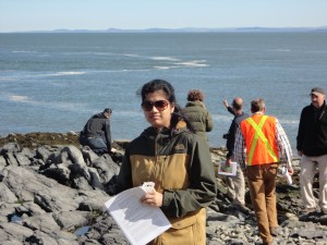
The first day of the conference was for the field trip, which was guided by the enthusiastic and knowledgeable seismologists and geologists. We started our journey at 8.30 am and visited 14 amazing sites at Charlevoix seismic zone. The sites include Pointe-au-Pic lookout, Gros Ruisseau, Sainte-Irenee-les-Bains, Ruisseau Jureux, Cap-aux-Oies, Les Eboulements – rang Saint Godefroy, Les Eboulements lookout, Saint Joseph-de-la-Rive, Les Ebulements –Seismograph station, Baie-Saint-Paul lookout, Highway 138 lookout, Saint-Urbain, Saint-Hilarion, Pointe-au-Pic.
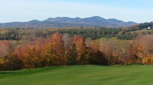
Our trip started with visiting the panoramic view of the Charlevoix impact structure. The highlands in the far background (Fig. 2) are the annular hills and central uplift centered on Mont-des-Eboulement. We visited the “Exotic” enclave of Ordovician limestone at faulted Precambrian basement. Another significant place was Les Eboulement considered as the epicenter of an earthquake (magnitude 6.5) on 20th October, 1870. The earthquake was so powerful that it caused landslide and liquefaction in the epicentral region. Two children were died and some dwellings were completely damaged (Nadeau, L et al. 2013).

Pointe-au-Pic lookout: Crater central uplift range and La Malbaie peripheral trough
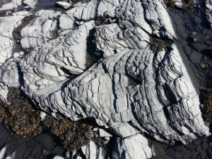
Our team has spent more than half an hour to visit Logan’s line and Appalachian front. The Appalacians are a linear mountain belt that was formed by the closure of the late Neoproterozoic-Early Paleozoic Iapetus and Paleozoic Rheic Ocean. It was really exciting to know that the mountain building process has a history of 480 million years. I had a chance to touch the Shatter cones in the Ordivician limestone. Shatter cones are rare geological features that are only known to form in the bedrock beneath meteorite impact craters. The azimuths of the cones’s axes typically radiate outwards from the point of impact, with the cones pointing upwards and toward the center of the impact crater. The typical feature of shatter cones is fractured surfaces which are developed in thick and more homogenous beds. At stop 13, we visited the shatter cones that were discovered by Dr. Rondot in 1966.

Shatter Cones near St-Lawrence river, cones pointing towards the impact structure

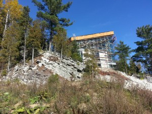
A newly constructed house right above the fault line shows a clear evidence of lack of awareness related to earthquake hazards among the inhabitants at Charlevoix, QC
I was thrilled to visit the village that is formed by the landslide debris. The Saint Joseph de-la-Rive landslide was caused by the February 5, 1663 earthquake. The nearby village was named as ‘Les Eboulement’ (meaning landfall). The day ends with visiting seismograph station at Charlevoix.
October 5, 2013 was a memorable day of my life because my dreams came true as a seismic risk researcher. Still missing the wonderful day when I was able to see earthquakes faults, landslide evidence and mountains that holds the history of millions years of the earth. Thanks to the organizers of the 85th Annual meeting of the Eastern Section Seismological Society of America and I am glad to have this opportunity in my lifetime.


