 If you are looking for images to spruce up a class presentation or a conference poster here are just a few of my favourites. Google Images may be the most obvious place to start, with the option to limit to faces, photos, clip art or line drawings, or to a particular size or colour. I use the colour option a lot to find images with a white or transparent background.
Flickr: Creative Commons is another resource that I use often. Here you can find images that others are willing to share, so that you can use them and credit whoever they belong to, based on a Creative Commons license as an alternative to copyright.
Most science magazines have image galleries online but I do love to browse NASA’s image gallery and 3D resources. They are generally not copyrighted and can be used with acknowledgements.
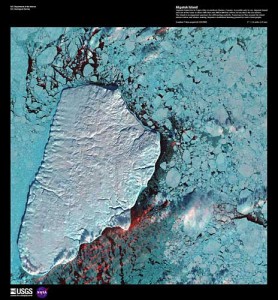
Lastly, there is a gorgeous set of images from the U.S. Geological Survey (USGS). The image gallery of the Earth Resources Observation and Science (EROS) Center contains the Earth as Art photo seen here. This is Akpatok Island, where native Inuit people hunt walrus and whales in northern Quebec, that “rises out of the water as sheer cliffs that soar 500 to 800 feet (150 to 243m) above the sea surface.” The USGS EROS Digital Image Gallery also includes land remote sensing images of the Journey of Lewis and Clark.
Happy viewing!
Image from USGS EROS Digital Image Gallery

